
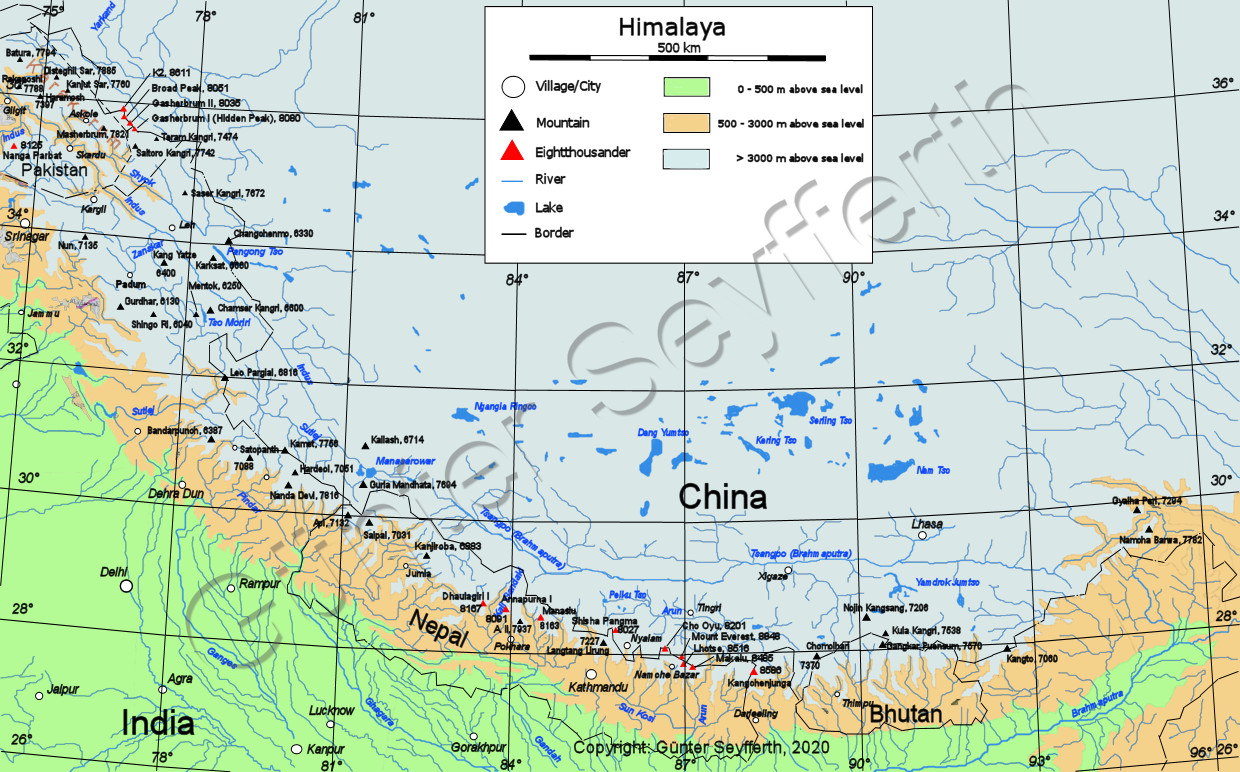
Significant part of Himalays as well as eastern Karakoram are located in India. Himalayas are located both in NW (parts of Punjab Himalaya: Jammu & Kashmir Himalaya and Himalchal Himalaya as well as Uttarakhand Himalaya) and NE (Sikkim, Assam Himalaya) parts of the country. NW part, particularly Garhwal and Kumaon regions of Uttarakhand Himalaya, are the most important areas in terms of mountaineering. Best known climbing objectives are to be found in Gangotri group with several high peaks culminating at Kamet (7756m) but somewhat lower peaks Thalay Sagar (6905m), Shivling (6543m) and stunning Bhagirathi and Arwa groups being the best known objectives. Perhaps the most famous peak of the country though is Nanda Devi (7816m) with several other high peaks surrounding it forming impressive Nanda Devi Sanctuary. Eastern parts are generally very little explored, although there are several high peaks also in that part of the country, e.g. Pauhunri (7128m) and Siniolchu (6887m).
General
Area structure
The main mountaineering areas in India are Garhwal and Kumaon groups on Uttarakhand Himalaya located in Utteranchal in the Northwestern India, not far away from the border of Nepal. For the purpose of this site, the structure described on The Indian Himalaya: A Brief Review is used consisting of the following sections:
- NW India Northwestern India covers both Eastern Karakoram as well as western part of Hiamalaya. It is by far the best known climbing area of India, as most of the highest and all of the best known peaks are located there. However, aside of well known areas of Gangotri and Nanda Devi in Uttarakhand, several far less explored areas further NW have large number of high peaks virtually no one has ever heard of.
- Eastern India East Indian Hiamalaya is certainly not as well known as the western ranges, in fact it is probably least known part of the whole range. Aside of Kanchenjunga located in Kanchenjunga Himal forming the border between Nepal and Sikkim, there are no other 8000m peaks or otherwise very famous peaks either. Siniolchu is sometimes referred to as one of the most beautiful peaks in the world, bit it is little known. Kanchennjunga aside, the highest peaks located in ranges associated with Eastern Indoa are Namche Barwa (7782m) and Gyala Peri (7352m), both of which are located on the Chinse part of Assam Himalaya.
- The Indian Himalaya: A Brief Review. The Himalaya, Karakoram and Hindu Kush ranges extend from Namcha Barwa in the east to the borders of Afghanistan in the west. Political maps show them as parts of India, Bhutan, Nepal, Pakistan and Afghanistan. A very large section of the Himalaya and an eastern section of the Karakoram, are in India. Broadly the Indian Himalaya consists of Arunachal, Sikkim, Uttarakhand, Himachal, Jammu & Kashmir and Eastern Karakoram. Though there are no 8000 m peaks in India except the Kangchenjunga, there are several peaks which are above 7000 m and a few of them are still unclimbed. A large number of peaks between 6000 to 7000 m are challenging and still virgin. Mountaineers in India have plenty of scope for exploration and conquest. At Indian Mountaineering Foundation.
- Expeditions In Himalayas. If you want to push yourself to the limits, then the Himalayas is the place to be. The mighty Himalayas offer you the most challenges that you can ever dream of. At Oriental Bliss Tours.
Climbing info
Rules and regulations
Mountain climbing in India is regulated by Indian Mountaineering Foundation (IMF). However, rules and regulations vary between different states. Aside of Nanda Devi Sanctaury ban, some areas are affected by restrictions or bans due to border disputes. Full details about the peaks available for climbing, regulations, fees etc. can be found on their website (link below).
- Some areas of Himachal (Spiti and Kinnaus at least) are reported to be free to all without a permit.
- There are handful of trekking peaks.
- Other opened peaks can be applied to. The permission is granted by IMF but the number of parties visiting a certain area and peak annually is limited, and numerous reports mention issues in getting a permit as well as already granted permit being denied.
- Uttarakhand was at least considering a permission system of their own (which would be on top of all fees and regulations set by IMF). Not sure what's the status regarding to this. If it materialised it sounded like it would make Uttarakhand peaks would require some serious bureoucracy and rather deep pockets. Somewhat different from most other such schemes, here it sounded like the driving force behind the whole system was pretty much the aim to relive visiting climbers of their money.
There appears to be quite a few trekking guidebooks as well as climbing guidebooks to several areas, mostly published by Harish Kapadia. Better yet, they all appear to available in English. Unfortunately based on Google book previews they don't generally include route topos or even grading. In addition to those, there are several trekking guides to various areas.
- Climbing in the Himalaya Region. Information about the regulations and fees of climbing in Himalaya.
- Bookings and Regulations. Information about expedition formalities in various countries. At UIAA.
- Indian Mountaineering Foundation. Full details about the peaks available for climbing, regulations, fees etc. can be found on their website.
- India Opens 100+ Peaks. More than a hundred previously restricted peaks in India's Jammu and Kashmir regions will open to climbing this upcoming season. As reported in the December 29, 2009 NewsWire, the India Mountaineering Federation and India's Ministry of Tourism had proposed the measure last year; now with approval from India's Ministry of Defense and Ministry of Home Affairs, the measure will go into effect this summer, opening at least 104 mountains. By Erik Lambert at Alpinist on 2010-04-19.
Grading
Most commonly used grading system is French adjectival system (IFAS). However, NCCS system is also sometimes used. Ice pitches are most commonly graded with steepness, however very steep routes are often graded with WI grade or sometimes Scottish grade. Rock pithes have traditionally been graded with uiaa rock grade. However, depending on which system the first ascent party was most familiar with, yds or french rock grades may be used instead. Rock grade is accompanied with standard aid climbing grade whenever applicable.
References
When considering that most of the highest peaks are located in Himalaya, actual climbing guidebooks are surprisingly few. However, lots of good information is to be found in Alpine Journals and other such publications, though usually they cover just the difficult stuff. Also the information in Journals and magazines is scattered around, so some significant research is in order.
Lack of consistent peak names and altitudes can present a burden when trying to gather the information though.
- : World Mountaineering - The World's Greatest Mountains by the Worlds Greatest Mountaineers. Isbn: 1845331427. Miller's Publications, 2006.
- : Hiker's and Climber's Guide to the World's Mountains and Volcanos, 4 Edition edition. Isbn: 9780944510186. Kelsey Publishing (Utah), 2001.
- : Himalaya Alpine Style - The Most Challenging Routes on the Highest Peaks. Isbn: 9780898864564. Mountaineers Books, 1996.
- : High Asia - An Illustrated History of the 7000 Metre Peaks. Isbn: 9780044404804. Harpercollins Publishers Ltd, 1990.
- : The Big Walls - From the North Face of the Eiger to the South Face of Dhaulagiri. Isbn: 9780898868449. Mountaineers Books, 2001.
- American Alpine Journal. Published since 1929, The American Alpine Journal is the premiere annual record of significant mountaineering and long rock climbing ascents worldwide. Some content and complete index available online. Search feature seem to lead complete pdf articles. At American Alpine Club.
- Alpine Journal. A record of mountain adventure and scientific observation since 1863. Alpine journal by British Alpine Club. Complete articles available as pdf for volumes 1969-2008, indexes for earlier volumes. At British Alpine Club.
- Mountain Info. Mountain Info is an international mountaineering information service which has been in existence for over 25 years. When Mountain Magazine ceased publication, High took over this important reporting duty. And again when High was finished, Mountain Info was took over by Climb. They have Mountain Info available as pdf files (requires free login) since it was taken over by Climb (starting from #483, Climb #1 (March 2005)). At Climb Magazine.
- Alpinist. Alpinist Magazine is an archival-quality, quarterly publication dedicated to world alpinism and adventure climbing. The pages of Alpinist capture the art of ascent in its most powerful manifestations, presenting an articulation of climbing and its lifestyle that matches the intensity of the pursuit itself.
- Himalayan Index. The Himalayan Index, an extensive record of expeditions to Asian peaks over 6000m. Chronicles ascents in the Greater Ranges and which cites references to the various climbing literature available. At British Alpine Club.
- Himalayan Journal. Published since 1929, it is the most authentic and authoritative reference on the activities in the Himalaya. It covers climbing, explorations, scientific observations and almost all aspects related to the Himalaya. The contributors include some of the best writers and climbers active in the range. In 2006 Volume 62 is published. At Himalayan Club.
- overview map. They also have interactive version with links to area-specific maps. At himalaya-info.org.
- Maps of Himalaya / Karakorum / Hindu Kush / Hindu Raj. Good collection of maps of Himalaya and beigbouring areas. Particularly US U502 series and Russian maps have very good detailed area maps At Blank on the Map.
- Trekking (Topographic). At Great Himalaya Trail.
- Himalaya. List of most important peaks. At Alpex High Alpine Expeditions.
- Everest News. Big site containing information about the expeditions to high mountains.
- Himalayan Climbs. The Ascent Book - a record of climbs in the Himalaya, Karakoram and Hindu Kush mountains. Our mountaineering database includes climbs on Everest, Manaslu, Kamet, the Muztagh Tower, Trango Towers, Meru, Shivling, Gurla Mandhata and many other peaks. If you've made a climb in the region and it isn't included, please help by submitting your ascent. At Himalayan Journeys.
NW India

General
Area structure
Northwestern India covers both Eastern Karakoram as well as western part of Hiamalaya. It is by far the best known climbing area of India, as most of the highest and all of the best known peaks are located there. However, aside of well known areas of Gangotri and Nanda Devi in Uttarakhand, several far less explored areas further NW have large number of high peaks virtually no one has ever heard of.
- Eastern Karakoram Eastern Karakoram.
- Ladakh Range
- Zanskar Range Zanskar range covers large area and particularly in Himachal Pradesh the highest peaks of Zanskar range are higher than those on Great Himalaya range. However, it is not particularly clear what grioups are considered part of Zanskar and what belong to Great Himalay Range. Thiis is particularly confusing in the west where Nun, KJun and Zanskar 1 are often considered part of Zanskar range. However, by far the most logical division would be to consider Stod and Suru valleys to separate the two. This would place the aforementioned peaks to Great Himalaya range.
- Great Himalayan range
- Pir Panjal range
However, instead of using mountain ranges as privipal dicision method, it is more customary to dive areas based on status. Thus NW India are usually divided into three main areas:
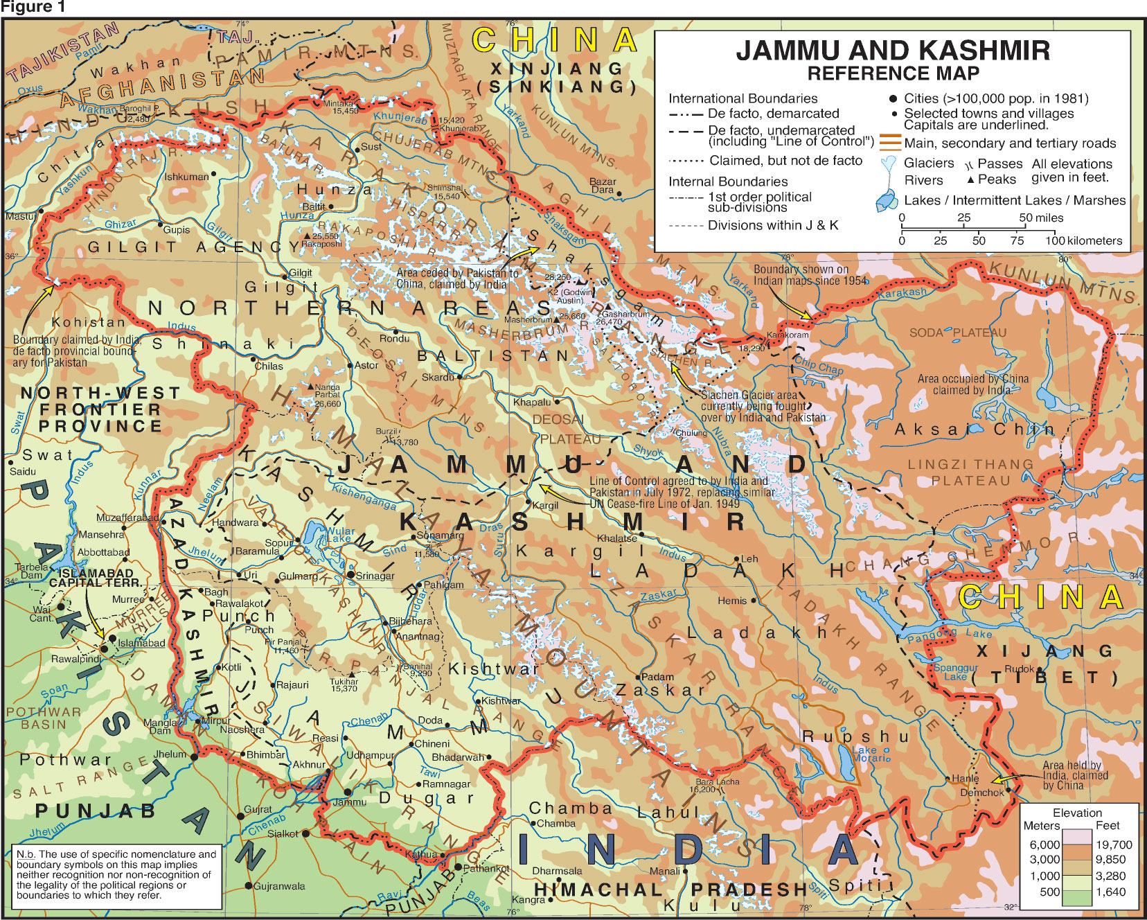
- Jammu-Kashmir Himalaya Jammu-Kashmir Himalaya is the westernmost of Himalayan areas in NW corner of India. The area is nowhere near as famous among climbers as areas further to the east. The highest and most famous peak of Jammu & Kashmir Hiamalaya is Nun in Nun Kun massif. However, lower peaks of Kishtwar are likely the most spectacular ones. The same general area has also higher peaks in Karakoram. Srinagar is the main convenient center for climbers visiting Jammu & Kashmir areas. Leh in Ladakh region is the other main base.
- Himachal Himalaya Himachal forms the central part of NW Indian Himalayas. The highest peaks are located in NE part of the state, but there are almost as high peaks (~6500m) on several other ranges. Current metering makes Gya (Gaya, 6794m) the highest peak of the state. Formerly Leo Pargial was quoted to be higher at 6816 but its current height is lower at 6791. Earlier Shilla was quoted to be over 7000m high, but its official altitude is much more modest 6123m. None of the peaks are of international fame. Miyar valley is probably the best known part of Himachal among foreign climbers. Main city of Himachal Pradesh is Shimla, located in SE of the state, to the south of all mountain chains.
- Uttarakhand Himalaya Main mountaineering area of India. Best known climbing objectives are to be found in Gangotri group and peaks around Nanda Devi Nanda Devi (7816m). Nanda Devi is likely the most famous peak in the country with several other high peaks surrounding it forming impressive Nanda Devi Sanctuary.
Climbing info
General
Uttarakhand Himalaya, particularly Garhwal and Kumaon regions are the most important areas in India in terms of mountaineering. Best known climbing objectives are to be found in Gangotri group with several high peaks culminating at Kamet (7756m) but somewhat lower peaks Thalay Sagar (6905m), Shivling (6543m) and stunning Bhagirathi and Arwa groups being the best known objectives. Perhaps the most famous peak of the country though is Nanda Devi (7816m) with several other high peaks surrounding it forming impressive Nanda Devi Sanctuary.
Peaks further NW in Jammu & Kashmir and Himachal Pradesh are generally somewhat lower and less famous. That being said, there are several very flashy peaks in these parts as well, for example in Kisthwar group.
Weather and conditions
Best season varies depending on the location of the area, as the furthest to the west and north the area lies, the less it is affected by monsoon. Eastern areas, such as Garhwal and Nanda Devi are affected by the monsoon from June to early September. These areas have two climbing seasons: premonsoon from April to early June and post-monsoon from early September to late October. Generally spring is warmer but post-Monsoon has more settled weather. Nanga Parbat in the far western end of Himalayan range is not really affected by the monsoon. There the most favorable season is similar to Karakoram: June-August.
References
- : Trekking and Climbing in the Indian Himalaya (Trekking & Climbing), 1 Edition edition. Isbn: 9780811729536. Stackpole Books, 2001.
- : High Himalaya Unknown Valleys. Isbn: 9788173871177. Indus Publishing Company,india, 2002.
- : Into the Untravelled Himalaya. Isbn: 9788173871818. Indus Books, 2005.
- : Meeting the Mountains, 1st edition. Isbn: 9788173870859. Indus Publishing Company, 1998.
- : Lonely Planet Trekking in the Indian Himalaya (Walking), 5 Edition edition. Isbn: 9781740597685. Lonely Planet, 2009.
- : Exploring the Highlands of Himalaya. Isbn: 9788173871887. Indus Publishing Company, 2007.
- : The Himalayan Experience - Introduction to Trekking and Climbing in the Himalaya. Isbn: 9780731800292. Simon & Schuster, 1989.
- Area overview map. At Himalaya Trekker.
- Overview map of Karakoram & Kashmir. At Hartmut's mountaineering page.
- Overview map of NW Indian areas
- Indian Mountaineering Foundation. Full details about the peaks available for climbing, regulations, fees etc. can be found on their website (link below).
- The Indian Himalaya: A Brief Review. The Himalaya, Karakoram and Hindu Kush ranges extend from Namcha Barwa in the east to the borders of Afghanistan in the west. Political maps show them as parts of India, Bhutan, Nepal, Pakistan and Afghanistan. A very large section of the Himalaya and an eastern section of the Karakoram, are in India. Broadly the Indian Himalaya consists of Arunachal, Sikkim, Uttarakhand, Himachal, Jammu & Kashmir and Eastern Karakoram. Though there are no 8000 m peaks in India except the Kangchenjunga, there are several peaks which are above 7000 m and a few of them are still unclimbed. A large number of peaks between 6000 to 7000 m are challenging and still virgin. Mountaineers in India have plenty of scope for exploration and conquest. At Indian Mountaineering Foundation.
Jammu-Kashmir Himalaya
General
Jammu-Kashmir Himalaya is the westernmost of Himalayan areas in NW corner of India. The area is nowhere near as famous among climbers as areas further to the east. The highest and most famous peak of Jammu & Kashmir Hiamalaya is Nun in Nun Kun massif. However, lower peaks of Kishtwar are likely the most spectacular ones. The same general area has also higher peaks in Karakoram. Srinagar is the main convenient center for climbers visiting Jammu & Kashmir areas. Leh in Ladakh region is the other main base.
Jammu and Kashmir have four main mountain chains, all running parallelly in generally NW-SE direction:
- Ladakh range Ladakh range is the northernmost of Himalayan ranges, located to the north of Zanskar range and to the south of Masherbrum, Saltoro and Saser Karakorams.
- Zanskar range The Zanskar Range rises between Zanskar and Ladakh valleys, to the north of Himalaya main chain (Nun-Kun and Himachal Pradesh sections) and to the south of Ladakh. The range rises to ~6200m in the central part and up to ~6600m in the eastern part. The area in Eastern Zanskar, around Tso Morari lake is known as Rupshu. It contains two sub-ranges: Mentok Range to to the west of Tthe lake and Thalda Kurrni to the east. The latter is the highest part of Zanskar with few non-technical peaks around 6600m high.
- Main groups in Jammu & Kashmir are Nun Kun group and Kishtwar Himalaya. Particularly the latter is spectacularly dramatic range with great local relief. The highest and best known peaks in the western part of the range include Brammah I (6416m), Brammah II (6425m), Sickle Moon (6574m). The peaks is the Eastern part are slightly lower but perhaps more spectacular.
- Pir Panjal range Lower Pir Panjal range is located to the south of Vale Kashmir.
- : Across Peaks & Passes in Ladakh, Zanskar & East Karakoram. Isbn: 9788173871009. Indus Publishing Company, 1999.
- Jammu and Kashmir. At Kashmir Study Group.
- Tourist & Trekking map of Ladak & Zanskar and adjacent areas of Himachal Pradesh. At Sedum Roseum.
Areas
Ladakh
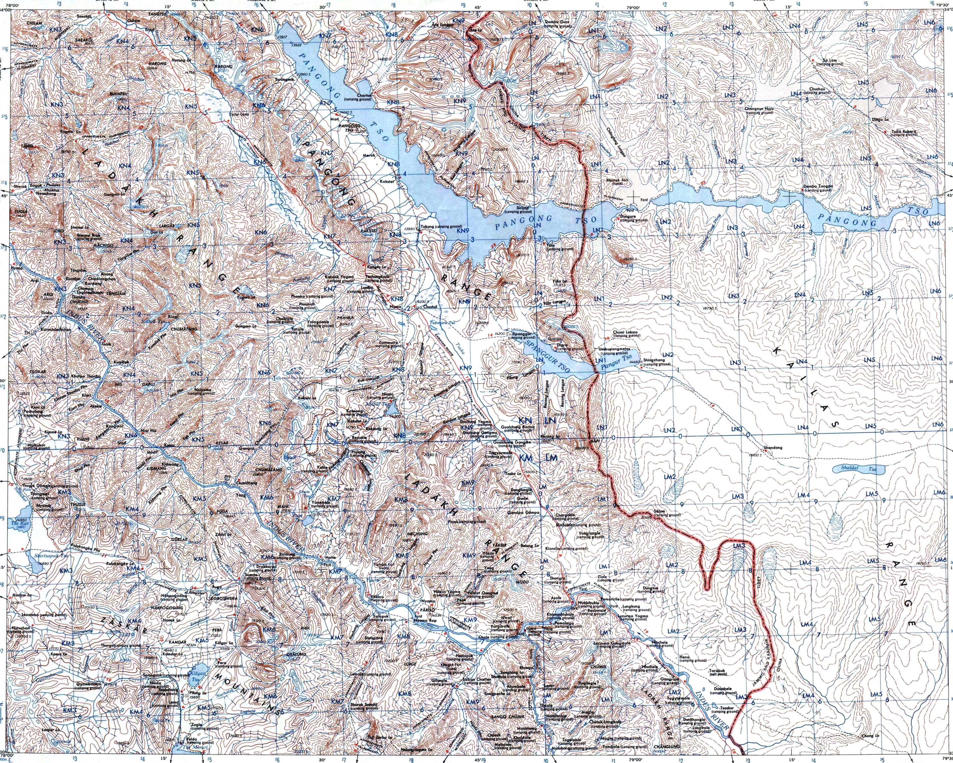
Ladakh has a landscape and culture similar to that of Tibet, hence it is sometimes called 'Little Tibet'. The area of Panggng lake has Kakstet peak (6442m) and the highest unnamed peak in the world (6725m). In south east Ladakh, in the Rupshu valley there are peaks as high as 6600m around the beautiful lake of Tso Morari. The highest amongst them are Lungser Kangri (6666m) and Chhamser Kangri (6622m). Indus river flows through Ladakh. The main base is the city of Leh.
Mountains
Pangong group
- Kangju Kangri (6725m)
- P. 6580 (6580m)
- Kakstet Peak (6442m)
- P. 6l34 (6134m)
Zanskar
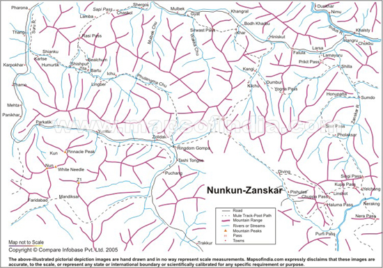
Entire barren valleys of Zanskar, due south of Ladakh, were once inaccessible. Currently road runs through the valley and the area is becoming one of the world's most popular trails. For serious climbers there are high peaks like Nun (7135m) and Kun (7087m). Easier objectives include peaks like Zanskar 1 (6181m) and Zanskar 2 (6175m).
Kashmir
Kashmir valley is known for centuries for its beauty and its fairly popular among trekkers. It is located due south of Greater Himalaya main, between it in NE and Pir Panjal range in SW. Srinagar is the main city of the area.
Small Kishtwar Himalaya, west of Lahaul along the Chandrabhaga river is particularly spectacular. It is a dramatic range of steep rock and ice peaks with great local relief. The highest and best known peaks in the western part of the range include Brammah I (6416m), Brammah II (6425m), Sickle Moon (6574m). The peaks is the Eastern part are slightly lower but perhaps more spectacular. The best known peaks include Hagshu (6300m), Kishtwar Kailash (6440m) and Cerro Kishtwar (6220m). Political disputes make accessing the area troublesome. The 1970s and ‘80s formed the heyday of Kishtwar climbing, as mountaineers, approaching from either Jammu or Srinigar via Kishtwar Village, explored first the more accessible western peaks, and later Eastern Kishtwar. Since then the area became politically problematic which rendered it very difficult to access. Virtually nobody went to the area in the 90's and 00's, however, in 10's the area has been visited by few parties. Particularly Mick Fowler has made several trips to the area both in the end of eighties and start of the 90's as well as on 10's, making difficult first ascents of Cerro Kishtwar and Kishtwar Kailash.
Mountains
Kashmir/Kargil
- Nun (7135m)
- Kun (7077m)
- Lingsarmo (6955m)
- Lingsarmo South (6800m)
Himachal Himalaya
General
Himachal forms the central part of NW Indian Himalayas. The highest peaks are located in NE part of the state, but there are almost as high peaks (~6500m) on several other ranges. Current metering makes Gya (Gaya, 6794m) the highest peak of the state. Formerly Leo Pargial was quoted to be higher at 6816 but its current height is lower at 6791. Earlier Shilla was quoted to be over 7000m high, but its official altitude is much more modest 6123m. None of the peaks are of international fame. Miyar valley is probably the best known part of Himachal among foreign climbers. Main city of Himachal Pradesh is Shimla, located in SE of the state, to the south of all mountain chains.
- Zanskar range Zanskar does not really extent to Himachal Pradesh according to classification here. The areas of Lahaul and Spiti sometimes associated with Zanskar range are considered part of Himalayan main range.
- Himalaya main range Entire NE part of Himachal Pradesh, north of Lahut valley from NW to SE separates Great Himalaya chain in the north from Pir Panjal range in the south belong to Great Himalaya chain. Highest peaks are located to the east. The highest peak in Himachal is Reo Purgyil (6816m) with several others not much lower. Shilla used to be given altitude of over 7000m; however current metering gives it a lot more modest altitude of 6132m.
- Pir Panjal range Pir Panjal is the largest range of the lesser Himalayas. It dissociates itself from the Great Himalayas near Manali and runs towards NW parallel to Himalayan main range forming the SW bank of Lahut valley. The range extends to Jammu & Kashmir as well as Pakistan Occupied Kashmir in Pakistan. The range extends to Jammu & Kashmir. The highest part of the range is located in the east. Deo Tibba (6001m) and Indrasan (6221m) are two most important peaks of the range.
- Dhaula Dhar Range.
- : Across Peaks & Passes in Himachal Pradesh. Isbn: 9788173870996. Indus Publishing Company, 1999.
- : Spiti - Adventures in the Trans-Himalaya, 2nd edition. Isbn: 9788173870934. Indus Publishing Company, 1999.
- : Guide to Trekking in Himachal Pradesh - Over 65 Treks and 100 Destinations. Isbn: 9788173871498. Indus Publishing Company, 2003.
- Mountain Info, #504 issue: 22, date: 2006-12.
- Mountain Info, #532 issue: 50, date: 2009-04.
Areas
Lahaul
The area north of the famous Rohtang Pass road consists of the valleys of Lahaul. Roads lead to almost all the valleys here and the approached are easy and free of hassle. Main center for expeditions to Spiti, Lahul, Zanskar and Ladakh is Manali.
Pangi valley
Main Pangi valley runs NW to SWE along Chehab river. The valley has three main side valleys towards north: Sural, Hudan and Saichu.
To the SW of the valley lies Pir Panjal range, West is Kisthwar Himalaya, and north Zanskar. Probably the most speactacular peaks from the valley is Shiva (6142m) located in Southern Kisthtwar. Other high peaks accessible from Pangi valley system are Menthosa (6443m) and Baihali Jot (6290m).
- American Alpine Journal, year: 2011, isbn: 9781933056715, pp: 294.'Pangi Valley, mountaineering history; unclimbed objectives from the Saichu Valley' by Bruno Moretti.
- Alpine Journal, year: 2002, pp: 54.'Climbing in Miyar Nala, Himachal Pradesh' by Antonella Cicogna & Mario Manica.
Miyar valley
Miyar valley has attracted several parties on 2000's. It is Indian version of Charakusa valley of Karakoram with varied objectives ranging from stunning rock routes to alpine peaks. The valley borders with Zanskar and Ladakh ranges. None of the peaks surrounding the valley are extremely high or particularly famous by itself. The draw of the valley is its selection of varied objects and significantly reduced bureaucracy and cost compared to more famous Gangotri of Garhwal region.
- Mountain Info, #493 issue: 11, date: 2006-01.
- Mountain Info, #504 issue: 22, date: 2006-12.
- Mountain Info, #515 issue: 33, date: 2007-11.
- Mountain Info, #531 issue: 49, date: 2009-03.
- Mountain Info, #532 issue: 50, date: 2009-04.
- American Alpine Journal, year: 2008, isbn: 9781933056074, pp: 370.'Miyar Glacier, Pangi Valley, Zanskar, Kishtwar, exploration; crossings of Kang La (5,440m), Poat La (5,500m), Dharlangwala Jot (5,086m), Shopu Pass (3,400m)' by Lt. Cdr. Satyabrata Dam.
- Alpine Journal, year: 2002, pp: 54.'Climbing in Miyar Nala, Himachal Pradesh' by Antonella Cicogna & Mario Manica.
- Alpine Journal, year: 2005, pp: 134.'Miyar Nala 2004 - Exploring the Hidden Himalaya' by Jom Lowther, Graham Little & Kevin Kelly.
- American Alpine Journal, year: 2012, isbn: 9781933056753, pp: 289.'Miyar Valley, various ascents' by Gerhard Schaar.
- New alpine rock routes in India's Miyar valley. In September, a multi-national team of Jeremy Frimer (Canada), Oliver Metherall (UK) and Michel van der Spek (The Netherlands) made two first ascents of alpine rock climbs in India's Miyar Valley. By Lindsay Griffin at Alpinist on 2006-10-23.
- Big alpine rock walls in India's Miyar valley. In September 2005 two Polish mountaineers, David Kazlikowski and Michal Krol, made the first ascent of Lotos Peak (5630m), the summit immediately right of the 5800-meter Neverseen Tower above the Chhudong (a.k.a. Tawa) Glacier in India's Miyar Valley. By Lindsay Griffin at Alpinist on 2006-11-06.
- New alpine rock routes in undeveloped Miyar valley. Over four weeks in August and September, an American team of three—Pat Goodman, Freddie Wilkinson and Dave Sharratt—established four new routes in the Miyar Valley, Himachal Pradesh, India. By Luke Bauer at Alpinist on 2007-10-01.
- New alpine rock routes in undeveloped Miyar valley. Over four weeks in August and September, an American team of three—Pat Goodman, Freddie Wilkinson and Dave Sharratt—established four new routes in the Miyar Valley, Himachal Pradesh, India. By Luke Bauer at Alpinist on 2007-10-01.
- Slovaks climb difficult new route in Miyar valley. Two Slovakian mountaineers, Andrej Kolarik and Juraj Svingal, made the first ascent of a new route on the unclimbed central pillar of Point 5930m in India's Miyar Valley. They named the peak Rachu Tangmu, which means Cold Horns, because the main summit takes the shape of two horns when viewed from the lower valley. By Vlado Linek & Andrej Kolarik at Alpinist on 2007-11-13.
- More new routes in India's Miyar valley. "We decided on this destination because there are no climbing permits or bureaucracy problems that are so typical for the rest of the Indian Himalaya. The area is getting more and more explored, but there are still some very interesting walls with no or only a few climbing routes to-date." By Andrej Grmovsek at Alpinist on 2007-11-26.
- Miyar Valley, new climbs by Schaar and Peschel in India. In summer 2011 Gerhard Schaar and Ines Peschel visited the Miyar Valley (India) where they established a series of new routes. By Planetmountain at Planet Mountain on 2012-02-27.
- Miyar valley, first ascent of Lotus Tower SE Face. In August 2014 an expedition comprised of the alpinists Cyrill Bösch, Elias Gmünder, Arunas Kamandulis and Gediminas Simutismade the first ascent of Splitter and Storm (500m, TD 6a), a new route up the unclimbed SE Face of Lotus Tower, Miyar Valley, India. The report by Gediminas Simutis. By Planetmountain at Planet Mountain on 2014-10-22.
Upper Miyar
The four main valleys on the east side of the upper Miyar are from north to south, Jangpar, Dali (formerly Thunder or Spaghetti), Chhudong (Tawa) and Takdung. Particularly Dali and Tawa valleys have been visited by quite a few climbers, who usually set up base camp near the entry to the gorges and the beginning of Miyar glacier (3950m), 40km from Tingrat village.
Formerly unnamed.
- American Alpine Journal, year: 2009, isbn: 9781933056098, pp: 299.'Toro Peak, south face, Direttissma; Tamadonog, Long Life Ridge' by Camilo Lopez.
- American Alpine Journal, year: 2014, isbn: 9781933056838, pp: 340.'Miyar Valley, Sanjana Peak (5,937m), southwest ridge; Mt. Sealth (5,968m) east ridge; David’s 62 Nose (4,950m), southwest face, Emerson-Owen Route' by Tim Halder.
Formerly Tawa.
- American Alpine Journal, year: 2009, isbn: 9781933056098, pp: 296.'Miyar Valley, Dome Peak (5,650m), Lopez-Pfaff Direct; Point JAMES (4,965m), Southeast Ridge' by Camilo Lopez.
- American Alpine Journal, year: 2012, isbn: 9781933056753, pp: 289.'“Mont Maudit”, northwest face and north ridge' by Martin Klonfar.
- American Alpine Journal, year: 2013, isbn: 9781933056791, pp: 310.'Forgotten Peak (5,889m), southeast face, Never Ending Story' by Michal Apollo.
- American Alpine Journal, year: 2013, isbn: 9781933056791, pp: 312.'Chhudong Valley, new routes and second ascents' by Magda Drozd-Rys.
- American Alpine Journal, year: 2014, isbn: 9781933056838, pp: 340.'Miyar Valley, Masala Peak (5,650m), Los Crotos (not to summit); Neverseen Tower (5,750m), Changa Style (not to summit)' by Lucas Alzamora.
Chandra valley
Chandra valley/Chander valley is the main valley in the western part of Lahaul & Spiti. It runs from NW-SE along Chehab-Chandra river before turning towards NW before Kunzum pass.
Towards its NW of Chandra river and east of Miyar valley lie Mulkilla group with Phabrang (6172m) and Mulkilla (6517m). Further east Koa Rang and Chandra Bhaga groups. Both have several peaks over 6000m high.
- Mountain Info, #493 issue: 11, date: 2006-01.
- Mountain Info, #506 issue: 24, date: 2007-02.
Bara Shigri glacier
Bara Shigri is the largest glacier in Himachal Pradesh. Bang Shigri group with ~25 peaks around 6000m high rise around the glacier offering climbers objectives of varying levels of difficulty. The northern bank of the glacier contains chain of high peaks: Central Peak (6285m) - Lion Peak (6126m) - Snow Cone (6309m) - Shigri Parbat (6626m). This northern chain meets the southern chain consisting of: Lalana (6265m) - Papsura (6451m) - Dharmsura (6446m) - Cathedral (6100m) - Kullu Pumori (6553m) - Parbati Parbat (6633m) at Dibibokri col. The southern chain separates Bara Shigri glacier glacier from Parvati valley system (Kullu) in the south.
Mountains
Agyasol group
- Agyasol (6200m)
Tupendo group
- Tupendo II (5700m)
- Druld Tupendo I (5700m)
Gupta group
- Gupta Peak (6000m)
- Kalidahar Spires (5900m)
Agyasol group
- Agyasol (6200m)
Tupendo group
- Tupendo II (5700m)
- Druld Tupendo I (5700m)
Gupta group
- Gupta Peak (6000m)
- Kalidahar Spires (5900m)
Miyar group
- Menthosa (6444m)
- Phabrang (6172m)
- Gangstang (6162m)
- Three Peaks Mountain (5845m)
Koa Rang group
- Koa Rang II (6187m)
- Koa Rang IIV (6258m)
Chandra Bhaga group
- Minar (6172m)
- Akela Killa (6005m)
- Chandra Bhaga 46 (5996m)
- Chandra Bhaga 53 (6093m)
North chain
- Central Peak (6285m)
- Lion Peak (6126m)
- Snow Cone (6309m)
- Shigri Parbat (6626m)
- Khhang Shiling (6360m)
SW chain
- Lalana (6265m)
- Papsura (6451m)
- Dharmsura (6446m)
- Cathedral (6100m)
- Kullu Pumori (6553m)
- Kulu Makalu (6349m)
- Corner Peak (6050m)
- Parbati Parbat (6633m)
SE chain
- Dibibokari Pyramid (6408m)
Spiti
Spiti is the most barren Trans-Himalayan area. In the east, the highest peak is the defiant Gya (6794m), still unclimbed. The controversial Shilla (6132m) stands proudly above this valley. In the west lie Ratang, Gyundi and Khamengar valleys. Khangla Tarbo is one of the better known peaks here. No permits needed!
- Spiti valley. At Maps of India.
- Spiti region map
- Spiti. At Moran Mountaineering.
- Spiti
- Detailed map of Spiti. At Blank on the Map.
- Detailed map of Spiti. At Blank on the Map.
- American Alpine Journal, year: 2011, isbn: 9781933056715, pp: 300.'Spiti, Singekang Valley, Singekang (6,008m), attempt; Snaght Kang (5,500m), north ridge' by Jeremy Windsor.
Pare Chu valley
The Pare Chu lies northeast of the Spiti River, not far from the Indo-Tibet border. Since 1995 it has been easy for foreign mountaineers to gain access to the areas west of the Spiti River, but the regions north and east are restricted.
Northern bank of the valley is somewhat less continuous than the southern bank. Here the main peaks are P. 6231m, P. 6210m, P. 6204m and P. 6122, all rising to the north of village of Dutung.
SE border of the valley system is formed by chain of high peaks running from SW to NE to Tibetan border: Kang Nilda (6303m) - Labrang (~5900m) - Shilla (6123m) - Lhakhang (6250m) - Parilungbi (6166m) - Lama Kyent (6040m) - Gyadung (6160m) - Gya (6794m). The peaks on this chain are accessed from Pakshi Lamur valley or the valleys further east
- Mountain Info, #493 issue: 11, date: 2006-01.
- Mountain Info, #506 issue: 24, date: 2007-02.
- American Alpine Journal, year: 2006, isbn: 9781933056012, pp: 391.'Pare Chu region, Thongsal' by Tsuneo Suzuki .
- American Alpine Journal, year: 2009, isbn: 9781933056098, pp: 304.'Pare Chu region, Thongsal' by David Oliveras.
- Pare chu valley. At Expedicion Spiti Valley 2008.
- Pakshi Lamur area. At Expedicion Spiti Valley 2008.
Lingti valley
Upper Lingti valley is surrounded by high peaks: Kang Nilda (6303m) - Labrang (~5900m) - Shilla (6123m) - Lhakhang (6250m) - Parilungbi (6166m) - Lama Kyent (6040m) - Gyadung (6160m) - Gya (6794m) - Parkyokula. Several ridges branch from this surrounding ridge and reach into Lingti. The most important of these is the ridge from Gyadung which contains 6000ers Geling (~6100m) - Runse (6175m) - Gyakar (6400m) and Tangmorma (6232m).
- American Alpine Journal, year: 1988, isbn: 9780930410339, pp: 235.'Climbs in the Lingti Valley, Spiti' by Harish Kapadia.
- Alpine Journal, #AJ 1988 pp: 57.'A Return to Lingti, 1987' by Harish Kapadia.
- Alpine Journal, year: 1990, pp: 57-62.'A Return to Lingti, 1987' by Harish Kapadia.
- Himalayan Journal, year: 1988.'A Return to Lingti, 1987' by Harish Kapadia.
Kinnaur
Kinnaur lies NE of Shimla, along the river Sutlej. The National Highway leads through Kinnaur to Spiti. Recent changes in policy allow visitors entry to the area west of the road without official permission. Which means, high peaks like Jorkanden (6473m), Manirang (6593m) and several others are now easily accessible. Above the eastern valleys of Baspa, Tirung and Leo Pargial (6791m) rise many peaks above 6000 m.
- Himalayan Journal, year: 1987.'A note on Kinnaur' by Harish Kapadia.
- Alpine Journal, year: 1989, isbn: 9780091736590, pp: 29-34.'A note on Kinnaur' by Harish Kapadia.
Baspa valley
Large valley to the east from the lower Kinnaur valley, due south of Kinnaur Kailash group.
- Mountain Info, #506 issue: 24, date: 2007-02.
Tirung valley
Next major valley north of Baspa valley, to the north of Kinnaur Kailash group. North side of the valley also contains peaks over 6000m high, such as Sesar Rang (6095m).
Gyamthan valley
Hanrang valley/Leo Pargial
Upper part of Kinnar valley leading to Leo Pargial (6791m).
Ropa Gad
Main valley NW of main Kinnaur valley, located more or less opposite Gyamthan valley. the valley can be followed to SE side of Manirang.
Mountains
Kinnaur East group
- Phawararang (6349m)
Kinner-Kailash range
- Kinner Kailash (6050m)
- Jorkanden (6473m)
Southern Kinnaur
- Rangrik Rang (6553m)
Kullu
Kullu area is a major attraction area for those who prefer to climb difficult but low peaks. The south Parvati area has peaks like Dibibokari, Pyramid, Papsura and Peak (6127m). The area is open to all climbers with peaks like Mukarbeh and Indrasan (6221m), and has a lot to offer hobbyists and serious climbers alike. Parvati valley is very long and complex valley system towards east. It as well as its numerous northern tribunaries (e.g. Malana glacier) are main approaches to climbs on the higher peaks.
Main Kullu valley runs south to north in central Himachal Pradesh. At the end of the valley rise several steep peaks forming high wall that separates Kullu valley from Chandra river valley in the north (Lauhal) with Hanuman Tibba - Makerbeh - Manali Peak - Ladekhi Peak - Rohtang Pass - Hamla Pass - Deo Tibba (6001m). The road road Kullu valley crosses this wall through Rohtang pass. Kullu in the central part of the valley is the main city of the area.
Parvati valley
Parvati valley is very long and complex valley system towards east. It as well as its numerous northern tribunaries (e.g. Malana glacier) are main approaches to climbs on the higher peaks. High peaks of Deo Tibba (6001m) and Indrasan (6221m)
- Mountain Info, #506 issue: 24, date: 2007-02.
- Himalayan Journal, year: 1954.'The Dibibokri basin ... and beyond' by Kenneth Snelson.
Mountains
North chain
- Central Peak (6285m)
- Lion Peak (6126m)
- Snow Cone (6309m)
- Shigri Parbat (6626m)
- Khhang Shiling (6360m)
SW chain
- Lalana (6265m)
- Papsura (6451m)
- Dharmsura (6446m)
- Cathedral (6100m)
- Kullu Pumori (6553m)
- Kulu Makalu (6349m)
- Corner Peak (6050m)
- Parbati Parbat (6633m)
SE chain
- Dibibokari Pyramid (6408m)
Kangra Himalaya
- Hanuman Tibba (5929m)
- Shikarbeh (6201m)
- Mukarbeh (6060m)
- Peak 6127 (6127m)
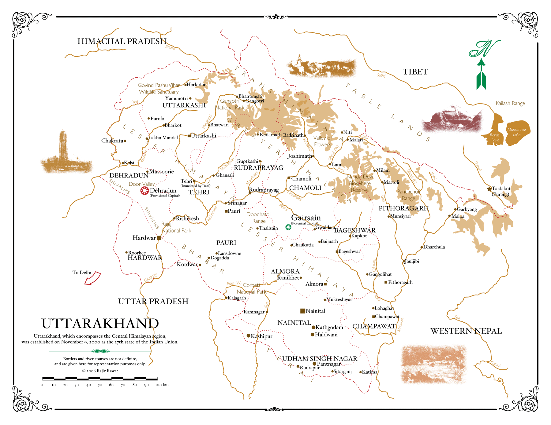
Uttarakhand Himalaya
General
Main mountaineering area of India. Best known climbing objectives are to be found in Gangotri group and peaks around Nanda Devi Nanda Devi (7816m). Nanda Devi is likely the most famous peak in the country with several other high peaks surrounding it forming impressive Nanda Devi Sanctuary.
Area structure
- Bandarpunch group Bandarpunch is the westernmost group of Uttarakhand Hiimalaya, located to the west of Bhagirathi river. The region houses some very easy, gentle peaks. Main peaks of the group are Swargarohini (6252m) and Bandarpunch (6316m) in SW part and Changsil Range in NE.
- Gangotri group Wild peaks gathered around Gangotri glacier SE of Gangotri town. Some of the most difficult climbing ever done has taken place on the walls of Thalay Sagar, Shivling, Meru, Bhagirathi and Arwa group. Several routes of Piolet d'Or level are testament to this. Kedar Dome is probably the best known objective among somewhat easier peaks.
- Kamet group Located to the east of Saraswati valley. Despite the fact that the highest mountains of Garhwal are to be found in this group, they are still somewhat overshadowed by more famous peaks around Gangotri.
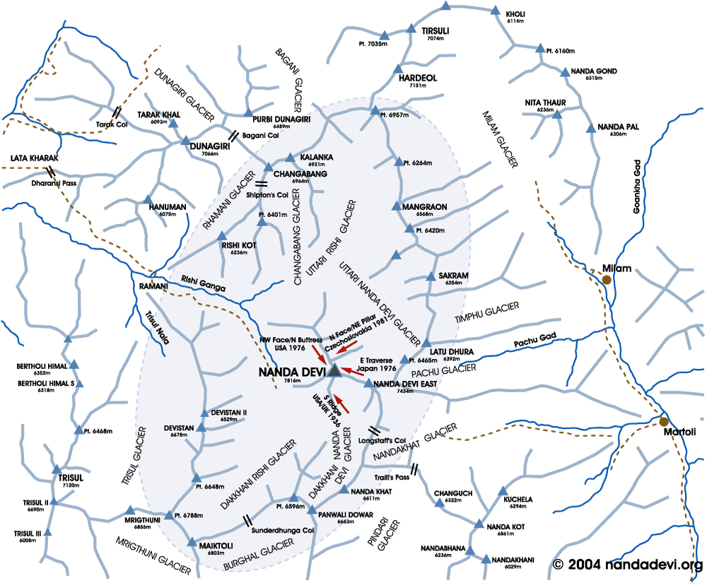
- Nanda Devi group Nanda Devi group forms a westwards opening Horseshoe of high peaks above Rishi gorge known as Nanda Devi Sactuary. Nanda Devi (7816m) is the highest peak in Indian Himalaya (23rd highest in the world) and arguably the most beautiful. There are several other highly noteworthy peaks on the rim of the Sanctuary like Changabang (6864m), Dunagiri (7066m) and Kalanka (6931m).
- Panchchuli group Located to the east of Nanda Devi group located from it by the Gori river (Munsiyari). The range runs from NW to SE. The group has several peaks around 6500m culminating at Panch Chuli II (6904m).
- Kalapani group Far eastern part of Uttarakhand Himalaya, located close to Nepal border.The highest peaks of the area are Sangthang (6430m) and P. 6172. The area is probably the least known part of Uttarakhand Himalaya.
About climbing in Uttarakhand
Highest peak of Indian Himalaya, Nanda Devi (7816m, 26th highest peak in the world) and its surrounding peaks form impressive Nanda Devi Sanctuary. Nanda Devi main summit is off-limits to climbers, at least for the time being. However, somewhat lower east summit as well as other peaks located in Nanda Devi Sanctuary can be climbed from outside the Sanctuary. Well, climbing permit can be obtained but whether they can actually be climbed is a matter of skill and determination, as some of the peaks are very difficult and are domain of serious bad-asses only. Highlights of Nanda Davi area include mountaineering classics Changabang, Dunagiri and Kalanka.
Perhaps even wilder peaks are to be found gathered around Gangotri glacier a bit further to the west. Some of the most difficult climbing ever done has taken place on the walls of Thalay Sagar, Shivling, Meru, Bhagirathi and Arwa group. Several routes of Piolet d'Or level are testament to this. Kedar Dome is probably the best known objective among somewhat easier peaks.
Central and western parts of the area are less famous. However, the second highest peak of Garhwal, Kamet (7756m), lies in central part of the range.
- : Across Peaks and Passes in Kumaun Himalaya, 1 Edition edition. Isbn: 9788173870965. Indus Publishing Company, 1999.
- : Across Peaks and Passes in Garhwal Himalaya, 1 Edition edition. Isbn: 8173870977. Indus Publishing Company, 1999.
- Garhwal Himalaya. At SummitPost.
- Garhwal Himal Peaks. Photo gallery. At flickr.
Areas
Bandarpunch
The valleys to the extreme west of the Garhwal region house some very easy, gentle peaks. Of most interest in this area is Swargarohini group with Bandarpuch West and Bandarpuch (6316m) have been climbed a couple of times. For a quick trip from Delhi this area is the most convenient.
Mountains
Bandarpunch group
- Swargarohini (6252m)
- Swargarohini II (6247m)
- Swargarohini III (6209m)
- Swargarohini IV (5966m)
- Bandarpunch (6316m)
- Bandarpunch II (6102m)
- Kalanag (6387m)
Gangotri Area
Gangotri is the largest glacier in Garhwal Himalaya. Access to Gangotri glacier valley and to valleys further to the west is from Hindu pilgrim town of Gangotri (3100m, 30.98,78.93). Despite the summits in Saraswati-Mana areas being generally higher, the peaks scattered around Gangotri glacier are much better known. The mountains are often very steep with huge rocky walls rising vertically for hundreds of meters above the glaciers. Several of those located around Gangotri glacier are legendary climbing peaks that are regularly featured in climbing literature. Several ascents in the peaks like Thalay Sagar, Shivling, Meru, Bhagirathi and Arwa Tower have become legendary and few of them can be found on the list of Piolet d'Or winners.
Western valleys of Rudugaira (to Auden's Col, 5468m) and Kedar Bamak are accessed from Gangotri to gain access to peaks forming the western border of Gangotri glacier from outside Gangotri circle. The former is leads to west side of Jogin while the latter gives access to NE sides of Thalay Sagar and Jogin.
Gangotri glacier extends to terminus at Gaumukh (4255m, 18km from Gangotri) and running 30km towards SE. The main Gangotri glacier has three main tributaries, namely Raktvarn (16km) and Chaturangi (including Kalandini bamak) (22,5km) in the NE and Kirti (11km) in west and numerous smaller tributary glaciers. The glacier or its tribunes are used to access most climbs in Gangotri area.
Mountains
SW Gangotri
- Chaukhamba I (7138m)
- Chaukhamba South (6974m)
- Kedarnath (6940m)
- Kirti Staumbh (6270m)
- Bharte Khunta (6578m)
- Kedar Dome (6831m)
- Sumeru Parbat (6331m)
- Kharchakund (6612m)
- Mandari Parbat (6193m)
- Chaukhamba II (7070m)
- Chaukhamba IV (6854m)
- Parvati Parvat (6257m)
- Nilkanth (6596m)
- Thalay Sagar (6905m)
- Bhrigupanth I (6773m)
- Bhrigu Parbat (6041m)
- Manda I (6510m)
- Manda II (6568m)
- Manda III (6529m)
- Meru North (6450m)
- Meru Central (6310m)
- Meru South (6660m)
- Shivling (6543m)
- Gangotri (6672m)
- Gangotri II (6599m)
- Gangotri III (6577m)
NE Gangotri
- Satopanth (7075m)
- Chandra Parbat (6730m)
- Chandra Parbat II (6728m)
- Swachhand (6590m)
- Sri Kailas (6932m)
- Kalidhang (6373m)
- Chirbas Parbat (6529m)
- Matri (6721m)
- Yougeshwar (6678m)
- Trimukhi Parbat (6422m)
- Bhagirathi Parvat I (6856m)
- Vasuki Parvat (6792m)
- Bhagirathi II (6512m)
- Bhagirathi IV (6193m)
- Bhagirathi III (6454m)
- Mana Parvat I (6794m)
- Mana Parvat II (6771m)
- Chaturangi (6407m)
- Arwa Tower (6352m)
- Arwa Spires (6193m)
Alaknanda/Saraswati
Alaknanda/Saraswati is a long valley running in south-north direction leading from Joshimathi in the south via Badrinathh, Mana and Ghastoli to the Mana-pass on border to Tibet. The valley divides Garhwal to western and eastern parts. Starting point for all peaks accessible from Alaknanda/Saraswati valley including its tributary valleys is Joshimath (1890m, 30.57,79.57).
The main valley is used to access several side valley, most important of them being Alaknanda, Pantapia Glacier (Nilkanth from south and west), Satopanth glacier, Bhagirath Kharak glacier and Arwa glaciers towards west (all used to access peaks forming the eastern border of Gangotri glacier, such as Satopanth and Arwa group) and Kamet-glacier in the east (Muku Parbat, Abi Gamin, Kamet).
Mountains
Mountains
- Chaukhamba I (7138m)
- Chaukhamba South (6974m)
- Kedarnath (6940m)
- Kirti Staumbh (6270m)
- Bharte Khunta (6578m)
- Kedar Dome (6831m)
- Sumeru Parbat (6331m)
- Kharchakund (6612m)
- Mandari Parbat (6193m)
- Chaukhamba II (7070m)
- Chaukhamba IV (6854m)
- Parvati Parvat (6257m)
- Nilkanth (6596m)
- Thalay Sagar (6905m)
- Bhrigupanth I (6773m)
- Bhrigu Parbat (6041m)
- Manda I (6510m)
- Manda II (6568m)
- Manda III (6529m)
- Meru North (6450m)
- Meru Central (6310m)
- Meru South (6660m)
- Shivling (6543m)
- Gangotri (6672m)
- Gangotri II (6599m)
- Gangotri III (6577m)
- Satopanth (7075m)
- Chandra Parbat (6730m)
- Chandra Parbat II (6728m)
- Swachhand (6590m)
- Sri Kailas (6932m)
- Kalidhang (6373m)
- Chirbas Parbat (6529m)
- Matri (6721m)
- Yougeshwar (6678m)
- Trimukhi Parbat (6422m)
- Bhagirathi Parvat I (6856m)
- Vasuki Parvat (6792m)
- Bhagirathi II (6512m)
- Bhagirathi IV (6193m)
- Bhagirathi III (6454m)
- Mana Parvat I (6794m)
- Mana Parvat II (6771m)
- Chaturangi (6407m)
- Arwa Tower (6352m)
- Arwa Spires (6193m)
Mountains
- Kamet (7756m)
- Abi Gamin (7355m)
- Mana I (7272m)
- Mukut Parvat (7242m)
- Mana NW (7092m)
- Saraswati Parvat I (6940m)
- Chamrao Parvat I (6910m)
- Gauri Parbat (6708m)
- Hathi Parbat (6726m)
Dhauli Ganga
Nanda Devi Sanctuary at the head of Rishi Ganga is, the center piece of the Garhwal region. Until 1934 the gorge of the Rishi Ganga was the least known part of the Himalaya. Nanda Devi (7816m) is the highest peak in Indian Himalaya (23rd highest in the world) and arguably the most beautiful. There are several other highly noteworthy peaks on the rim of the Sanctuary like Changabang (6864m), Dunagiri (7066m) and Kalanka (6931m).
The inner Sanctuary is closed for mountaineering for unforeseeable future due to natural protection reasons. Should the Sanctuare be reopened, starting point for approach through Rishi Ganga would be Joshimathi (1890m, 30.57,79.57). Most peaks forming the borders of Sanctuare are still available for climbing from the outside of Sanctuary. These are generally accessed eitherPindari and Milam valleys (see Kumaon for further details).
- Nanda Devi group. At Photo Journal.
- Nanda Devi Sanctuary and Milam glacier. At Great Himalaya Trail.
- Nanda Devi. At This Mountains of Central Asia Digital Dataset (MCADD).
Mountains
Dunagiri group
- Dunagiri (7066m)
- Purbi Dunagiri (6489m)
Milam group
- Hardeol (7151m)
- Tirsuli I (7074m)
- Tirsuli II (7035m)
Sanctuary NE
- Mangraon (6568m)
- Deo Damla (6620m)
- Sakram (6254m)
- Latu Dhura (6392m)
Nanda Devi
- Nanda Devi (7816m)
- Sunanda Devi (7434m)
Trisul group
- Trisul I (7120m)
- Bethartoli (6352m)
- Bethartoli South (6318m)
- Trisul II (6690m)
- Trisul III (6007m)
Kumaon
Kumaon consists of several valleys located to the west of Nepal.
The western valley of Kumaon is the Pindari valley, flanked by peaks like Panwali Dwar (6663m) and Nanda Khat. This area is very popular with climbers. The Sunderdhunga valley branches off from the Pindari and leads to the southern foot of the Nanda Devi Sanctuary.
The Central valley in the Kumaon is large Milam glacier valley. It is long valley running from Munsiyari (2290m, 30.0715174,80.2373401) - Ramganga and Saryu valleys - Martoli - Gori Ganga - Milam glacier. From Martoli side valley to west leads to Nanda Devi East base camp. At the head of the Milam glacier are the enticing peaks Hardeol (7151m) and Tirsuli (7074m). Beside its eastern branch is an excellent climbing area of Kalabaland glacier. The peak Chiring We (6559m) rises from the Kalabaland glacier. To its south, is Suitilla (6373m) a most formidable and difficult goal.
Panch Chuli is the south eastern valley of this section in the Kumaon. It has five different peaks which were conquered with great difficulty, both from the East and the West.
Darma Ganga/Lassar Yankti valley. At its head are several technical peaks above 6000m like Sangthang and Lalla We.
Mountains
Milam group
- Hardeol (7151m)
- Tirsuli I (7074m)
- Tirsuli II (7035m)
Sanctuary NE
- Mangraon (6568m)
- Deo Damla (6620m)
- Sakram (6254m)
- Latu Dhura (6392m)
Panch Chuli massif
- Panch Chuli II (6904m)
- Panch Chuli I (6355m)
- Panch Chuli III (6312m)
- Panch Chuli IV (6334m)
- Panch Chuli V (6437m)
Chiring We massif
- Kalanga Dhura (6215m)
- Bamba Dhura (6334m)
- Chiring We (6559m)
- Suli Top (6300m)
- Trigal (5983m)
- Suitilla (6373m)
- Chaudhara (6510m)
- Rajrambha (6539m)
- Nagalaphu (6410m)
Eastern India

East Indian Hiamalaya is certainly not as well known as the western ranges, in fact it is probably least known part of the whole range. Aside of Kanchenjunga located in Kanchenjunga Himal forming the border between Nepal and Sikkim, there are no other 8000m peaks or otherwise very famous peaks either. Siniolchu is sometimes referred to as one of the most beautiful peaks in the world, bit it is little known. Kanchennjunga aside, the highest peaks located in ranges associated with Eastern Indoa are Namche Barwa (7782m) and Gyala Peri (7352m), both of which are located on the Chinse part of Assam Himalaya.
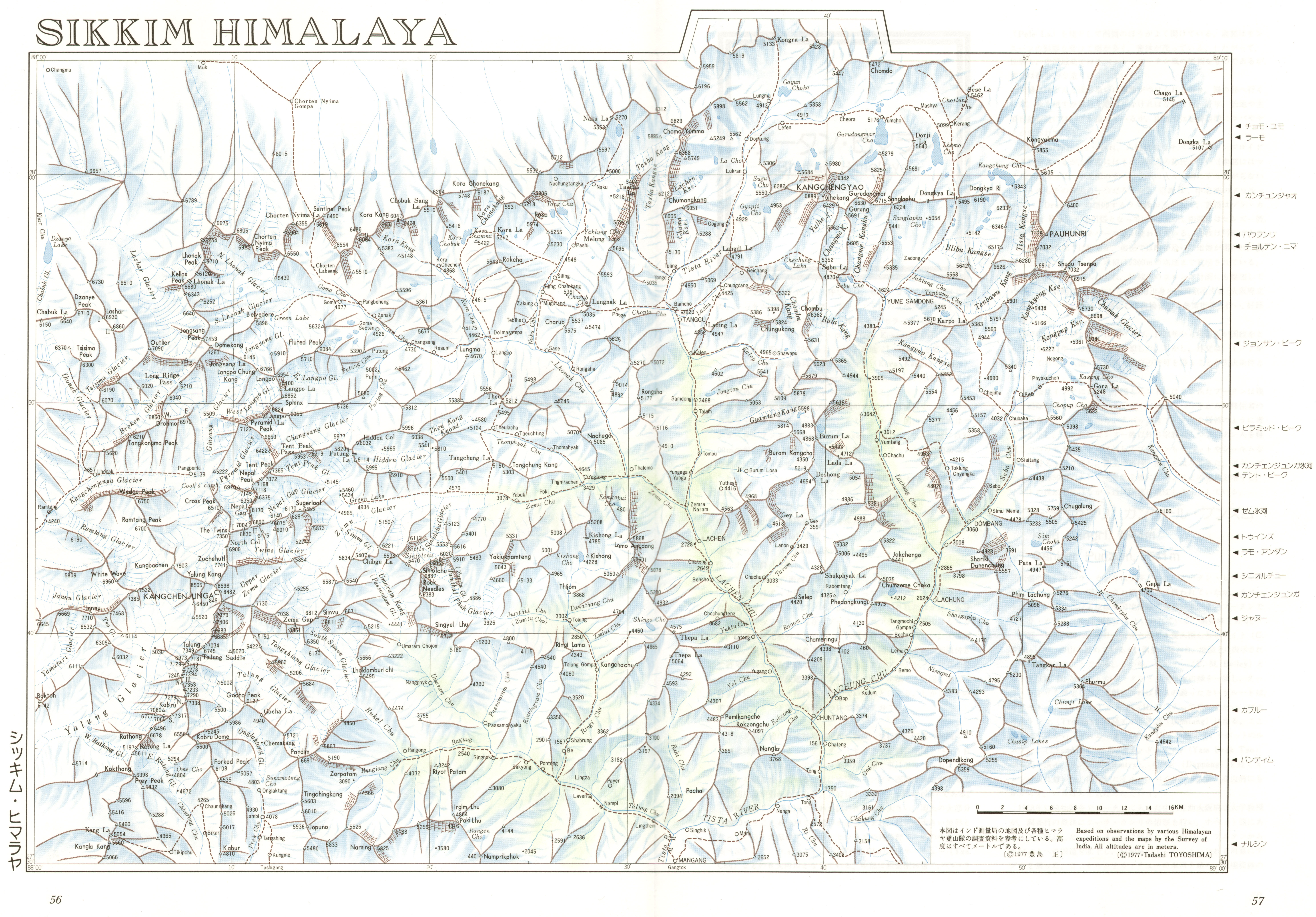
- Sikkim Himalaya Sikkim is Indian district located between Nepal in west, China (Tibet) in north and Bhutan in east. Generally poor weather and frequent snowfall produce spectacular flutings and corniced crests much more akin with Peruvian mountains than those of the Himalaya. The range is dominated by massive Kangchenjunga (8586m), the easternmost 8000m peak. There are several high peaks, including several unclimbed 7000m peaks.
- Assam Himalaya Assam Himalaya is the easternmost part of Himalaya. The area is partly located in Indian states of Assam and Arunachal Pradesh while other parts lie in southeastern Tibet. The area is generally least known part of the Himalays despite there being several very high peaks culminating at Namche Barwa (also Namjagbarwa, 7782m), Gyala Peri (7293m) and Kangto (7090m).
Sikkim Himalaya
Sikkim is Indian district located between Nepal in west, China (Tibet) in north and Bhutan in east. Generally poor weather and frequent snowfall produce spectacular flutings and corniced crests much more akin with Peruvian mountains than those of the Himalaya. The range is dominated by massive Kangchenjunga (8586m), the easternmost 8000m peak. There are several high peaks, including several unclimbed 7000m peaks.
Mountains of Sikkim are renowned for their poor weather, frequent snowfall and general cloud cover. The considerable precipitation (Kangtok has annual rainfall of 3250mm) on these often steep sided peaks produces spectacular flutings and corniced crests much more akin with Peruvian mountains than those of the Himalaya.
The range is dominated by massive Kangchenjunga (8586m), the easternmost 8000m peak. Little is known about the area and access is complicated. However, there are several high peaks, including several unclimbed 7000m peaks. Sikkim has defined few peaks as "Alpine Peaks", which means small teams can easily obtain permission and at modest cost.
- West Sikkim West Sikkim consists of several ridges extending east from Kanchenjunga Himal main ridge forming the border between Nepal (west) and Sikkim (east). The highest and best known peak of the area is Kanchenjunga. of the peaks located completely in Sikkim, Siniolchu (6888m, often considered to be one of the most beautiful mountains of the world) is probably the best known.
- North Sikkim North Sikkim consists of Chorten Nyima and Dongkya ranges. The former is west-east chain of high 6000ers forming the natural border between Tibet in the north and Siukkim on the south. The latter is located in NE part of Sikkim, culminating at Pauhunri (7128m).
- East Sikkim Chola range forms the border between Sikkim (west) and Bhutan (east). The highest peak of the range is Rishila.
- Darjeeling Himalaya Lower peaks to the south of Sikkim, close to city of Darjeeling.
Darjeeling, lying some 70km south of Kangchenjunga is the most conveniently located starting point for climbs in Sikkim, despite strictly speaking it does not lie in Sikkim (West Bengal further south). The main city of Sikkim proper is Gangtok. For information about the regulations in regards to climbing in Sikkim, refer to links in Rules and regulations.
- : Across Peaks and Passes in Darjeeling and Sikkim. Isbn: 9788173871269. Indus Publishing Company, 2002.
- American Alpine Journal, year: 2007, isbn: 9781933056050, pp: 373.'Himachal Pradesh, Sikkim, Mountaineering Associations, Regulations, Fees, and Permitted Peaks'
- American Alpine Journal, year: 2008, isbn: 9781933056074, pp: 112-127.'Emerging from the mists' by Roger Payne.
- Sikkim Himalaya. At This Mountains of Central Asia Digital Dataset (MCADD).
- Sikkim map. At Himalayan Trekker.
- The Alpine Peaks of Sikkim. The Home Department of Sikkim has designated five newly opened Alpine Peaks to encourage small expeditions. They are: Frey Peak 5830m, Tinchenkang 6010m, Jopuno 5936m (West Sikkim) and Lama Wangden 5868m, Brumkhangse 5635m (North Sikkim). By Roger Payne at Alpinist on 2007-09-08.
- British-American Expedition Nabs FAs in Sikkim. This spring, based at camp from May 8-22, three Brits and one American climbed two notable first ascents in the western Sikkim region of India, both in alpine style. First they climbed the virgin west face of Lama Lamani North (5650m), likely the peak's second overall ascent. Then they made the first ascent of an unknown peak before attempting nearby Jopuno (5936m). By Andrew Freeman at Alpinist on 2010-09-01.
Areas
West Sikkim
West Sikkim consists of several ridges extending east from Kanchenjunga Himal main ridge forming the border between Nepal (west) and Sikkim (east). The highest and best known peak of the area is Kanchenjunga. of the peaks located completely in Sikkim, Siniolchu (6888m, often considered to be one of the most beautiful mountains of the world) is probably the best known.
There are several ridge systems towards east from Kanchenujunga Himal, located completely in Sikkim and reached from the Sikkim side. The largest of them being:
- Tent Peak – Putung La and further. Several peaks close to 6000m and few a little over.
- Kanchenjunga South – Zemu Gap – Simvu – Chibge La – Siniolchu. The ridge system is complex with numerous side branches. In particular it divides in two at Siniolchu. The northern branch is only separated by narrow col from North-south group of peaks forming western border of Lachen Chu valley and containing reasonable high peaks like Angdang (5868m)
- Kabru North – Kabru Dome – Pandim – Japuno (5936m). Complex ridge system with numerous side ridges
Mountains
Zemu group
- Zemu Peak (7780m)
- Simvo (6811m)
- Simvo Central (6811m)
- Siniolchu (6887m)
Pandim group
- Pandim (6691m)
Chorten Nyima range
Chorten Nyima range is located in NW corner of Sikkim, forming the border between Tibet (north) and Sikkim (south). It connects to Kanchenjunga Himal at Jongsang (7462m). The group contains several high 6000ers with Chorten Nyima (6927m) being the highest. None of the peaks in the range are famous.
- Himalayan Journal, year: 1940.'The Chorten Nyima La from the Tibetan side' by N.E. Odell & Peter Lloyd.
Mountains
Chorten Nyima range
- Chorten Nyima Ri (6927m)
- Kellas Peak (6680m)
- Lhonak Peak (6710m)
- Sentinel Peak (6490m)
- Kora Kang (6601m)
- Chorten Nyima Ri North West (6805m)
- P. 6789 (6789m)
- P. 6764 (6764m)
- Chomo Yummo (6829m)
Dongkya range
Dongkya range is located to the east of Chorten Nyima range. The range consists of
- West-east ridge with Kangchengyao (Gyao Chang , 6889m) - Yulhekhang (6429m) - Gurudongmar (6715m) - Sanglaphu (6224m) – Donkya La (5495m). Gurudongmar and the other peaks in the Kangchengo group have steep southern aspects; they are approached more easily from the north and have shorter ascents.
- North-south ridge with Chombu (6362m) running south from Yulhekhang (6429).
- Group between Donkya La (5495m) in the west and Karpo la in the East with Donkya Ri (6190m) – P. 6517 – P. 6626 – P. 6911.
- Pauhunri group forming the border between Sikkim (west) and Tibet (east) with the main peaks from north to south: Pauhunri (7128m) – Shudu Tsenpa (7032m) – P. 6730 – P. 6698 – Gora La.
- American Alpine Journal, year: 2012, isbn: 9781933056753, pp: 326.'The Plateau, rare photographic coverage' by Lindsay Griffin.
Mountains
Kangchengyao group
- Kangchengyao (6889m)
- Gurudongmar (6715m)
Pauhunri group
- Pauhunri (7128m)
- Shudu Tsenpa (7024m)
Assam Himalaya
Assam Himalaya is the easternmost part of Himalaya. The area is partly located in Indian states of Assam and Arunachal Pradesh while other parts lie in southeastern Tibet. The area is generally least known part of the Himalays despite there being several very high peaks culminating at Namche Barwa (also Namjagbarwa, 7782m), Gyala Peri (7293m) and Kangto (7090m).
Assam Himalaya is traditional designation of the eastern section of Great Himalayas between the eastern border of Bhutan, on the west, and the Great Bend of the Tsangpo River, on the east. The area is partly located in Indian states of Assam and Arunachal Pradesh while other parts lie in southeastern Tibet. The range runs west to east for 720km from the upper Tista River in the west to the great southward bend of the Brahmaputra River (there called the Tsangpo River) in the east.
The area is generally least known part of the Himalays among mountaineers despite there being several very high peaks culminating at Namche Barwa (also Namjagbarwa, 7782m). The major portion of Assam Himalaya is a low range by the Himalayan standards, between 5000 and 6000 metres high, and devoid of extensive mountaineering interest. That being said there are two significant exceptions: Namcha Barwa and Kangto sections.
Kangto group
The high range of the Kangto section is least known of all Himalayan area. It lies in a gigantic curve running roughly west-southwest and east-northeast between the passes of the Tulung la and Keshong la. Dominating peak of the range is Kangto (7060m).
Namche Barwa group
Namche Barwa (also Namjagbarwa, 7782m) and it's sister peak Gyala Peri (7295m)lie in the southeaster part of Tibet mark the eastern end of Himalayan range. They rise high above the canyon of Yarlung Tsanpo river in Medog county of China.
Mountains
Kangto group
Gorichen group
- Gorichen I (6488m)
- Gorichen (6488m)
- Gorichen East (6422m)
Kangto group
- Kangto (7090m)
- Kangto II (6953m)
- Yalaxianbo (6635m)
Nyegyi Kansang group
- Nyegyi Kansang (6983m)
- Chiumo (6890m)
- Tui Kangri (6883m)
- Tui Kangri SE (6750m)
- Takpa Shiri (6655m)
Gyalha Peri group
- Gyalha Peri (7295m)
- Tiba Kangri (6846m)
- Tiba Kangri South (6806m)
- Sendapu (6812m)
Namche Barwa group
- Namcha Barwa (7782m)
- Namcha Barwa II (7344m)
- Namcha Barwa III (7146m)
- Sanglung (7095m)
- Sanglung West (6809m)
- Nai Peng (7043m)
- Langjiapu (6936m)